To round out the week I participated in the hiking portion of our yearly ward outing. This year the ward camped at the Granite Flat campground in American Fork Canyon. We hiked from Silver Lake Flat Reservoir (a couple miles up a dirt road from Granite Flat) to Silver Lake.
I didn't count how many of us went on the hike, but it was a lot more people than I'm used to hiking with. You could safely say it was the largest group I've hiked in since I was a scout decades ago.
It hardly felt like we were in a big group, though. We pretty quickly spread out with the teens leading the way and those from my generation lagging behind (mostly because they were carrying kids of various sizes). I was somewhere in the middle.
I had never really hiked in American Fork Canyon before (except my nearly annual hikes up Mount Timpanogos) and I loved it. It's much more foresty than most of the other canyons around here. The trail was well-maintained and there were incredible views of Mount Timpanogos (that you never get while hiking the mountain itself).
The trail starts pretty flat but gets quite a bit steeper for the last 3/4 mile or so. It could also be that it just seems that way because you get start getting tired by then. Either way, it's not a terribly difficult hike.
There are many places where it seems like you should arrive at the lake just over the next little hill, only to discover another hill beyond that one.
Silver Lake itself is worth the trip. It has some beautiful still waters with high peaks and cliffs all around, as well as an incredible view down the canyon from on top of the dam.
It was 2.33 miles to the top (nearly 5 miles for me, total) and a climb of about 1,700 feet.
Saturday, July 12, 2014
Tuesday, July 8, 2014
Mount Millicent
One of the best things about our new house is having a next-door neighbor that also likes to hike, and who has been to places I've still never been. Casey (my neighbor) and I have decided to try to hike every other week through the rest of the summer, and our first hike was up to the top of Mount Millicent.
| Milly Express |
| View of Mount Millicent from way down below |
| Twin Lakes from the Dam |
We continued up the hill to the top of the lift and that's where the fun began. This was the part that I was most nervous about. We had to pick our way up a steep, rocky slope, as you can see in the picture below. It was like walking up a very irregular staircase.
| Casey looking for the best way up the mountain |
After a climb of 600 vertical feet we reached the top, and as we were taking in the impressive views the mosquitoes came out. We didn't see any near the lake, but a thousand feet higher at the top of the mountain they were everywhere.
| Lake Mary with Clayton, Pioneer, and Sunset peaks |
| Meese |
They didn't move. Had they been 50 feet off the trail we might have tried to cautiously get around them, but being close enough to the trail that we could poke them with our trekking poles we decided to backtrack up the hill a bit and find another way around.
We made it easily back to the lake, and from there back to the car and headed home. It was a great after-work hike that took us 1,900 feet up in a total of 3.6 miles. Yeah, that's steep.
Saturday, July 5, 2014
Lake Catherine (From Brighton)
The day after Independence Day we were invited to hike up above Brighton with some friends. Normally I try to stay away from the mountains during holiday weekends, but I really like hiking with these people and I figured it would be a good hike to take Titan on.
| Titan at Lake Mary |
| Lake Martha |
It was a bit of a struggle to make it to Lake Mary, but having been up the trail in the past I reassured everyone that the hard part of the trail was already done. Most of the group continued on to Lake Catherine (passing Lake Martha on the way). We found a snow bank just off the trail and had a snow ball fight (in July!)
| Panorama of Lake Catherine |
This was actually the first time in all the times I've been to Lake Catherine that I actually sat down at the water's edge and enjoyed being there. I'm always quick to arrive at my destination and then move on. It was nice to have the time to enjoy the moment a bit.
The hike was right near 4.5 miles, if I remember correctly, with about 1,700 feet of elevation gain.
Saturday, June 21, 2014
White Pine Lake - Maybe a Little Too White
When I first started hiking a couple years ago one of the first trails on my list was the trail to White Pine Lake in Little Cottonwood Canyon. Its relatively gentle slope and long length intrigued me a bit and I always wanted to go. The trail is five miles to the first view of the lake (don't believe the sign at the trail head that says it's only four. The trail starts at the White Pine Trail parking lot (pretty easy to remember) and climbs up over 10,000 feet.
Fortunately I was able to convince my brother-in-law Shawn to hike with me. I'm still a little leery about camping alone so far up, so it was nice to have some company. Plus, since he's in better shape than me he kept me moving forward even when I wanted to stop.
This time of year is always a little difficult for backpacking since all the highest elevations still have snow. We chose White Pine because there are quite a few good camping spots on the way up so if we were unable to make it all the way to the lake we'd be able to find a spot to sleep without heading all the way back home.
The trail begins by dropping a couple hundred feet to the river, then slowly climbs to the West for about a mile. At this point there's a sign pointing left for White Pine, and left for Red Pine. Yes, you read that right. The Redd Pine trail turns left also, but a few feet past the White Pine turn off.
We saw quite a few people on our way up to the junction, but very few after. I don't think White Pine is nearly as popular as Red Pine, but it certainly should be.
The trail has a few switchbacks and you gain elevation pretty quick, but within a mile from the junction the ground levels out a bit and there are some level areas where the hiking isn't too bad.
The picture above is the first time we saw where we were going. You can sort of make out the trail on the left side of the picture up in the snow. White Pine Lake sits just to the right of center behind the hill.
We saw a few more people as we climbed higher; a lot of them running the trail (crazies). About 3.5 miles in we stopped and talked to a couple that had been up at the lake. We asked how the snow was and if there would be any place to camp. They said that it was mostly snow-covered, but that there were already two tents up there and there might possibly be enough dry land for another one. That wasn't encouraging.
About 4 miles in we hit the snow. We had been climbing over small patches here and there, but our luck had run out. We would have to climb a couple hundred feet up a snow field to get to the lake.
In the above picture you can see the footprints on the right, and the trail up higher in the snow. In the picture below we're standing on the trail at the top looking back down to where we started in the snow.
The views from up on top were spectacular, though. We were over 10,000 feet (I forgot to check and see exactly how high) and just below some of the highest peaks in the Wasatch. The snow, though tricky and arduous to climb through, made the mountains look even more majestic and beautiful.
The next picture I took the next morning, looking back at the snowy trail. It was about half snow and half rocks, but the steep slope made it a little spooky on the snowy parts.
We dropped down into the little valley with White Pine Lake at the bottom. Most of the ground was covered in snow, and the only bare spots we could see already had tents. We kept sliding down the snow till we were almost at the lake and found a small patch of bare ground big enough and level enough for two tents. It even had a nice rock to cook dinner on.
We got camp set up, cooked dinner, and settled in for a cold night. After the sun went down about 9:00pm my thermometer dropped quickly from 70 down to 50. It was going to be cold. Every time I woke up during the night I checked the thermometer; it never dropped below 40.
In the morning the temperature had climbed all the way to 50 by 7:00am. We got up, ate breakfast, repacked our bags and headed out by 8:00am. The trip down was uneventful, except that the snow was much icier than it was the night before.
We made it back to the truck at about 10:15 and headed home to rest.
We ended up hiking a total of 10.3 miles, and climbed 2700 vertical feet or so.
Fortunately I was able to convince my brother-in-law Shawn to hike with me. I'm still a little leery about camping alone so far up, so it was nice to have some company. Plus, since he's in better shape than me he kept me moving forward even when I wanted to stop.
This time of year is always a little difficult for backpacking since all the highest elevations still have snow. We chose White Pine because there are quite a few good camping spots on the way up so if we were unable to make it all the way to the lake we'd be able to find a spot to sleep without heading all the way back home.
The trail begins by dropping a couple hundred feet to the river, then slowly climbs to the West for about a mile. At this point there's a sign pointing left for White Pine, and left for Red Pine. Yes, you read that right. The Redd Pine trail turns left also, but a few feet past the White Pine turn off.
We saw quite a few people on our way up to the junction, but very few after. I don't think White Pine is nearly as popular as Red Pine, but it certainly should be.
The trail has a few switchbacks and you gain elevation pretty quick, but within a mile from the junction the ground levels out a bit and there are some level areas where the hiking isn't too bad.
The picture above is the first time we saw where we were going. You can sort of make out the trail on the left side of the picture up in the snow. White Pine Lake sits just to the right of center behind the hill.
We saw a few more people as we climbed higher; a lot of them running the trail (crazies). About 3.5 miles in we stopped and talked to a couple that had been up at the lake. We asked how the snow was and if there would be any place to camp. They said that it was mostly snow-covered, but that there were already two tents up there and there might possibly be enough dry land for another one. That wasn't encouraging.
About 4 miles in we hit the snow. We had been climbing over small patches here and there, but our luck had run out. We would have to climb a couple hundred feet up a snow field to get to the lake.
In the above picture you can see the footprints on the right, and the trail up higher in the snow. In the picture below we're standing on the trail at the top looking back down to where we started in the snow.
The views from up on top were spectacular, though. We were over 10,000 feet (I forgot to check and see exactly how high) and just below some of the highest peaks in the Wasatch. The snow, though tricky and arduous to climb through, made the mountains look even more majestic and beautiful.
The next picture I took the next morning, looking back at the snowy trail. It was about half snow and half rocks, but the steep slope made it a little spooky on the snowy parts.
We dropped down into the little valley with White Pine Lake at the bottom. Most of the ground was covered in snow, and the only bare spots we could see already had tents. We kept sliding down the snow till we were almost at the lake and found a small patch of bare ground big enough and level enough for two tents. It even had a nice rock to cook dinner on.
We got camp set up, cooked dinner, and settled in for a cold night. After the sun went down about 9:00pm my thermometer dropped quickly from 70 down to 50. It was going to be cold. Every time I woke up during the night I checked the thermometer; it never dropped below 40.
In the morning the temperature had climbed all the way to 50 by 7:00am. We got up, ate breakfast, repacked our bags and headed out by 8:00am. The trip down was uneventful, except that the snow was much icier than it was the night before.
We made it back to the truck at about 10:15 and headed home to rest.
We ended up hiking a total of 10.3 miles, and climbed 2700 vertical feet or so.
Saturday, June 7, 2014
Broads Fork
Wednesday night I was finally able to get out after work and do a real hike. I've done a couple low elevation hikes this Spring but none of them were really worth writing about.
I was a bit unsure where to go. There's still snow in the highest elevations, and I've done a lot of hikes the last couple years. I didn't really want to repeat a hike when there are so many more to do.
After weighing my options I finally decided to head up the Broads Fork trail. It's the trail that leads to Twin Peaks (that tall peak you see between Big and Little Cottonwood Canyons). It was the shortest drive and the most intriguing of all my options.
The trail starts at the bottom of the S-Curve in Big Cottonwood Canyon. It's the same trail head as the trail to Lake Blanche, but instead of going South from the parking lot you go West.
The trail starts out steep and slowly gets steeper. In fairness, it also has a few flat spots. The trail stays in the trees most of the way up, but was a little overgrown in a few places. My legs got scratched up a bit trying to squeeze through the bushes.
I started hiking at about 5:30pm, having driven there straight from work. It felt great to be back out hiking in the canyons and seeing all the green in the trees and bushes. I didn't realize how much I missed the smell of the mountains until I got a half mile in. With the steepness of the trail I wasn't able to maintain my usual fast pace, but I still made pretty good time.
After about half a mile I heard some voices ahead of me just off the trail. I noticed there were some cliffs up on the right, and there were a couple guys (20ish) climbing around on them (or I imagined they were climbing around. In reality they were sitting at the bottom of the cliffs when I passed).
One of them asked me if I knew where the trail went. I was tempted to tell him it lead to the parking lot at the S-Curve, but figured he probably wanted to know where the other end of the trail went.
I told him that I wasn't really sure, but had heard that it leads to a couple meadows and eventually a few peaks. They must not have been impressed with my description, or were just lazier than they looked, because I didn't see them at any point higher up the trail. In fact I didn't see anyone else higher up on the trail than that.
About a mile in I started to hear the roar of the river and it was loud. Usually a roar like that only accompanies a waterfall. I caught a couple glimpses of the river through the trees and was impressed by the quantity of water coming down the mountain.
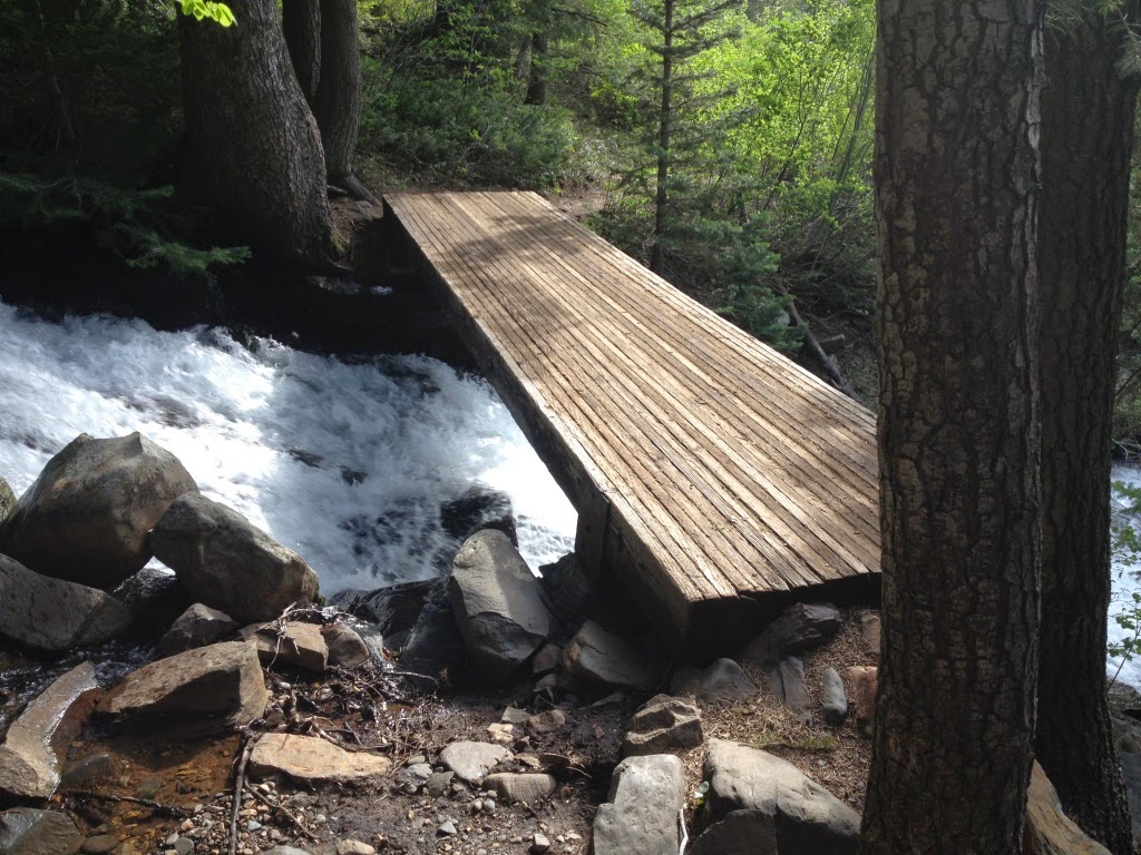
Fortunately there was a bridge across the river at about 1.2 miles and I was able to cross. I took a few pictures as I crossed and got a little dizzy seeing all the water roaring beneath me.
As I recall, the trail stays somewhat flat for a bit after crossing the bridge and for quite awhile the hiking is very pleasant. There were multiple times on this trail that I said to myself that that part of the trail was absolutely perfect. The trail was pretty soft in most places, had good shade, great smells. and occasional views. It was a great trail. Except for the parts that were too steep to be enjoyable, but even then all the other factors nearly made up for the steepness.
About a half mile from the bridge I entered the lower meadow. The trail dipped down a couple dozen feet (which is always a little frustrating because you know you have to make that elevation up again somewhere) and I had a short, flat respite from the relentless climbing.
According to my records, this meadow sits at about 7500', which is about 700 feet above the bridge just a half mile back. The upper meadow (my final destination) sits at 8200', another 700 feet up, and just a half mile further. That's an average slope of about 26%.
I was excited to reach the upper meadow, and not just because I knew I was finished climbing. It was beautiful to look back and see the canyon I'd just climbed, and look forward and see the snow on the peaks towering another 3000' over me. I spent some time exploring, taking some pictures, and eating a snack. I briefly considered hiking a bit farther but talked myself out of it when I saw the sun dip behind the mountain.
The trip down was uneventful and much faster than I expected. I saw 3 people within a half mile of the trailhead, two going down and a third coming up. It seems strange to me that with over 1 million people living within an hour of this trail I could be the only person that day to spend time in that meadow. I'm not complaining--I like the solitude--but it still boggles my mind how few people make the effort to get out and explore with so many beautiful places so close to home.
In all, I hiked 5 miles and climbed 2300'. It was a difficult hike but worth it in every way.
I was a bit unsure where to go. There's still snow in the highest elevations, and I've done a lot of hikes the last couple years. I didn't really want to repeat a hike when there are so many more to do.
After weighing my options I finally decided to head up the Broads Fork trail. It's the trail that leads to Twin Peaks (that tall peak you see between Big and Little Cottonwood Canyons). It was the shortest drive and the most intriguing of all my options.
The trail starts at the bottom of the S-Curve in Big Cottonwood Canyon. It's the same trail head as the trail to Lake Blanche, but instead of going South from the parking lot you go West.
The trail starts out steep and slowly gets steeper. In fairness, it also has a few flat spots. The trail stays in the trees most of the way up, but was a little overgrown in a few places. My legs got scratched up a bit trying to squeeze through the bushes.
I started hiking at about 5:30pm, having driven there straight from work. It felt great to be back out hiking in the canyons and seeing all the green in the trees and bushes. I didn't realize how much I missed the smell of the mountains until I got a half mile in. With the steepness of the trail I wasn't able to maintain my usual fast pace, but I still made pretty good time.
After about half a mile I heard some voices ahead of me just off the trail. I noticed there were some cliffs up on the right, and there were a couple guys (20ish) climbing around on them (or I imagined they were climbing around. In reality they were sitting at the bottom of the cliffs when I passed).
One of them asked me if I knew where the trail went. I was tempted to tell him it lead to the parking lot at the S-Curve, but figured he probably wanted to know where the other end of the trail went.
I told him that I wasn't really sure, but had heard that it leads to a couple meadows and eventually a few peaks. They must not have been impressed with my description, or were just lazier than they looked, because I didn't see them at any point higher up the trail. In fact I didn't see anyone else higher up on the trail than that.
About a mile in I started to hear the roar of the river and it was loud. Usually a roar like that only accompanies a waterfall. I caught a couple glimpses of the river through the trees and was impressed by the quantity of water coming down the mountain.
Fortunately there was a bridge across the river at about 1.2 miles and I was able to cross. I took a few pictures as I crossed and got a little dizzy seeing all the water roaring beneath me.
As I recall, the trail stays somewhat flat for a bit after crossing the bridge and for quite awhile the hiking is very pleasant. There were multiple times on this trail that I said to myself that that part of the trail was absolutely perfect. The trail was pretty soft in most places, had good shade, great smells. and occasional views. It was a great trail. Except for the parts that were too steep to be enjoyable, but even then all the other factors nearly made up for the steepness.
About a half mile from the bridge I entered the lower meadow. The trail dipped down a couple dozen feet (which is always a little frustrating because you know you have to make that elevation up again somewhere) and I had a short, flat respite from the relentless climbing.
According to my records, this meadow sits at about 7500', which is about 700 feet above the bridge just a half mile back. The upper meadow (my final destination) sits at 8200', another 700 feet up, and just a half mile further. That's an average slope of about 26%.
I was excited to reach the upper meadow, and not just because I knew I was finished climbing. It was beautiful to look back and see the canyon I'd just climbed, and look forward and see the snow on the peaks towering another 3000' over me. I spent some time exploring, taking some pictures, and eating a snack. I briefly considered hiking a bit farther but talked myself out of it when I saw the sun dip behind the mountain.
The trip down was uneventful and much faster than I expected. I saw 3 people within a half mile of the trailhead, two going down and a third coming up. It seems strange to me that with over 1 million people living within an hour of this trail I could be the only person that day to spend time in that meadow. I'm not complaining--I like the solitude--but it still boggles my mind how few people make the effort to get out and explore with so many beautiful places so close to home.
In all, I hiked 5 miles and climbed 2300'. It was a difficult hike but worth it in every way.
Sunday, March 16, 2014
Hurricane Rim/Canal Trail
We were still a bit worried about the weather on Saturday, the last day of the trip. The forecast called for a chance of rain throughout the day. However, the closer to Saturday we got the better the forecast looked. When we woke up Saturday morning the 60% chance had dropped to 30%.
It didn't really matter if it rained or not, though. This was the day I had been looking forward to the most and I wasn't going to change my plans. There was no flash flood danger on this trail, and I'd be sleeping in my own bed that night.
On this trip I tried to match my starting points to Mike's starting points so we wouldn't have to drive all over the place every day. I knew he was planning to meet his team in Hurricane so I scoured the internet for hikes in Hurricane. There were quite a few and they all looked pretty good. A lot of them required driving in on a dirt road, though. I eventually settled on the Hurricane Rim trail, with the option of dropping down to the Canal Trail.
Here in Northern Utah there are plenty of canal trails, but they're all just dirt roads running next to stinky canals. This canal trail follows a canal completed in 1904 with tunnels and bridges and stunning views along the whole length.
The trail starts at the Hurricane Hills trailhead just East of Hurricane on Highway 59 (the road to Colorado City). It follows the road to the East for awhile, then switches back up the hill. There's quite a bit of up and down, but no steep places. It was exactly the kind of trail I like.
At 1.85 miles the Canal Trail split off from the Rim Trail. My original plan had been to do a loop, following the Rim trail to the far end where it met with the Canal Trail, then return on the Canal Trail. That would have been at least 11 miles and I had read that there were some washouts on the Canal Trail that might have made a few of the miles difficult.
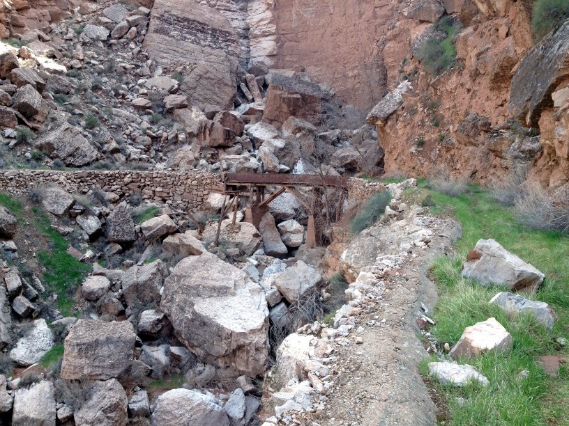
Instead, I decided to hike the Canal Trail as far as I could, backtrack to the Rim Trail, then continue up the Rim Trail to make up the miles. So I took the turnoff for the Canal Trail and dropped quickly down to the level of the canal. It was amazing to see something so old that was still mostly intact. The canal was still mostly in the shape of a canal, often with a steep drop off the side.
Within a few hundred feet I came to the first tunnel. It was neat to see, but a little short for a tall guy like me to walk through. Fortunately there was a way around the tunnel. The tunnel was a couple hundred feet long. It's pretty amazing to think about people being able to carve that out over a hundred years ago.
I followed the Canal Trail about a mile before I had to make another decision. There were a couple tunnels that had collapsed and the only way to get around was to drop down to the Virgin River hundreds of feet below, then climb back up to the canal farther up the canyon. After having already hiked 20+ miles in the last 48 hours I wasn't confident that I'd be able to climb back up from that far down; I had to leave enough strength to get back up from the canal, too.
So I decided to turn around and head back up to the Rim Trail. I got to see a couple tunnels, an old bridge, some great scenery, and walked a mile in a 100-year-old canal. That was enough.
The views along the Rim Trail were even better than I could have imagined. It felt like I could see forever in all directions. The rain over the last couple days had cleared the air so there was no haze, and the remaining clouds made for some beautiful pictures.
I think I took nearly 100 pictures on just this one trail. Every time I turned a corner the views got even better.
I'm sure these pictures aren't in order, but it all looked about the same.
There were a lot of cows out grazing. It was a lot more pleasant to come across cows in the light than it was in a dark a couple years ago up on Big Mountain. They're still pretty freaky to see when you're all alone. I always just talk to the cows now (in English. I don't speak Cow) and it seems to help.
I hiked another 2 miles up the Rim Trail so I could end up with a total of 10 miles by the end of the hike. I also climbed nearly 2,500 feet over the course of the hike, even though my end point probably wasn't more than 100 feet higher than where I started.
That put my trip total at 28 miles in 3 days. It was an amazing trip.
It didn't really matter if it rained or not, though. This was the day I had been looking forward to the most and I wasn't going to change my plans. There was no flash flood danger on this trail, and I'd be sleeping in my own bed that night.
On this trip I tried to match my starting points to Mike's starting points so we wouldn't have to drive all over the place every day. I knew he was planning to meet his team in Hurricane so I scoured the internet for hikes in Hurricane. There were quite a few and they all looked pretty good. A lot of them required driving in on a dirt road, though. I eventually settled on the Hurricane Rim trail, with the option of dropping down to the Canal Trail.
Here in Northern Utah there are plenty of canal trails, but they're all just dirt roads running next to stinky canals. This canal trail follows a canal completed in 1904 with tunnels and bridges and stunning views along the whole length.
The trail starts at the Hurricane Hills trailhead just East of Hurricane on Highway 59 (the road to Colorado City). It follows the road to the East for awhile, then switches back up the hill. There's quite a bit of up and down, but no steep places. It was exactly the kind of trail I like.
At 1.85 miles the Canal Trail split off from the Rim Trail. My original plan had been to do a loop, following the Rim trail to the far end where it met with the Canal Trail, then return on the Canal Trail. That would have been at least 11 miles and I had read that there were some washouts on the Canal Trail that might have made a few of the miles difficult.
Instead, I decided to hike the Canal Trail as far as I could, backtrack to the Rim Trail, then continue up the Rim Trail to make up the miles. So I took the turnoff for the Canal Trail and dropped quickly down to the level of the canal. It was amazing to see something so old that was still mostly intact. The canal was still mostly in the shape of a canal, often with a steep drop off the side.
Within a few hundred feet I came to the first tunnel. It was neat to see, but a little short for a tall guy like me to walk through. Fortunately there was a way around the tunnel. The tunnel was a couple hundred feet long. It's pretty amazing to think about people being able to carve that out over a hundred years ago.
I followed the Canal Trail about a mile before I had to make another decision. There were a couple tunnels that had collapsed and the only way to get around was to drop down to the Virgin River hundreds of feet below, then climb back up to the canal farther up the canyon. After having already hiked 20+ miles in the last 48 hours I wasn't confident that I'd be able to climb back up from that far down; I had to leave enough strength to get back up from the canal, too.
So I decided to turn around and head back up to the Rim Trail. I got to see a couple tunnels, an old bridge, some great scenery, and walked a mile in a 100-year-old canal. That was enough.
The views along the Rim Trail were even better than I could have imagined. It felt like I could see forever in all directions. The rain over the last couple days had cleared the air so there was no haze, and the remaining clouds made for some beautiful pictures.
I think I took nearly 100 pictures on just this one trail. Every time I turned a corner the views got even better.
I'm sure these pictures aren't in order, but it all looked about the same.
There were a lot of cows out grazing. It was a lot more pleasant to come across cows in the light than it was in a dark a couple years ago up on Big Mountain. They're still pretty freaky to see when you're all alone. I always just talk to the cows now (in English. I don't speak Cow) and it seems to help.
I hiked another 2 miles up the Rim Trail so I could end up with a total of 10 miles by the end of the hike. I also climbed nearly 2,500 feet over the course of the hike, even though my end point probably wasn't more than 100 feet higher than where I started.
That put my trip total at 28 miles in 3 days. It was an amazing trip.
Subscribe to:
Posts (Atom)