We were still a bit worried about the weather on Saturday, the last day of the trip. The forecast called for a chance of rain throughout the day. However, the closer to Saturday we got the better the forecast looked. When we woke up Saturday morning the 60% chance had dropped to 30%.
It didn't really matter if it rained or not, though. This was the day I had been looking forward to the most and I wasn't going to change my plans. There was no flash flood danger on this trail, and I'd be sleeping in my own bed that night.
On this trip I tried to match my starting points to Mike's starting points so we wouldn't have to drive all over the place every day. I knew he was planning to meet his team in Hurricane so I scoured the internet for hikes in Hurricane. There were quite a few and they all looked pretty good. A lot of them required driving in on a dirt road, though. I eventually settled on the Hurricane Rim trail, with the option of dropping down to the Canal Trail.
Here in Northern Utah there are plenty of canal trails, but they're all just dirt roads running next to stinky canals. This canal trail follows a canal completed in 1904 with tunnels and bridges and stunning views along the whole length.
The trail starts at the Hurricane Hills trailhead just East of Hurricane on Highway 59 (the road to Colorado City). It follows the road to the East for awhile, then switches back up the hill. There's quite a bit of up and down, but no steep places. It was exactly the kind of trail I like.
At 1.85 miles the Canal Trail split off from the Rim Trail. My original plan had been to do a loop, following the Rim trail to the far end where it met with the Canal Trail, then return on the Canal Trail. That would have been at least 11 miles and I had read that there were some washouts on the Canal Trail that might have made a few of the miles difficult.
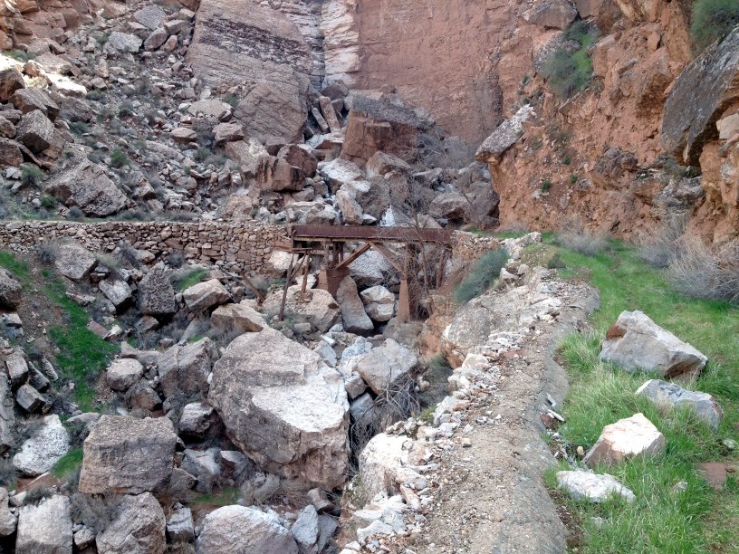
Instead, I decided to hike the Canal Trail as far as I could, backtrack to the Rim Trail, then continue up the Rim Trail to make up the miles. So I took the turnoff for the Canal Trail and dropped quickly down to the level of the canal. It was amazing to see something so old that was still mostly intact. The canal was still mostly in the shape of a canal, often with a steep drop off the side.
Within a few hundred feet I came to the first tunnel. It was neat to see, but a little short for a tall guy like me to walk through. Fortunately there was a way around the tunnel. The tunnel was a couple hundred feet long. It's pretty amazing to think about people being able to carve that out over a hundred years ago.
I followed the Canal Trail about a mile before I had to make another decision. There were a couple tunnels that had collapsed and the only way to get around was to drop down to the Virgin River hundreds of feet below, then climb back up to the canal farther up the canyon. After having already hiked 20+ miles in the last 48 hours I wasn't confident that I'd be able to climb back up from that far down; I had to leave enough strength to get back up from the canal, too.
So I decided to turn around and head back up to the Rim Trail. I got to see a couple tunnels, an old bridge, some great scenery, and walked a mile in a 100-year-old canal. That was enough.
The views along the Rim Trail were even better than I could have imagined. It felt like I could see forever in all directions. The rain over the last couple days had cleared the air so there was no haze, and the remaining clouds made for some beautiful pictures.
I think I took nearly 100 pictures on just this one trail. Every time I turned a corner the views got even better.
I'm sure these pictures aren't in order, but it all looked about the same.
There were a lot of cows out grazing. It was a lot more pleasant to come across cows in the light than it was in a dark a couple years ago up on Big Mountain. They're still pretty freaky to see when you're all alone. I always just talk to the cows now (in English. I don't speak Cow) and it seems to help.
I hiked another 2 miles up the Rim Trail so I could end up with a total of 10 miles by the end of the hike. I also climbed nearly 2,500 feet over the course of the hike, even though my end point probably wasn't more than 100 feet higher than where I started.
That put my trip total at 28 miles in 3 days. It was an amazing trip.


No comments:
Post a Comment