Wednesday night I was finally able to get out after work and do a real hike. I've done a couple low elevation hikes this Spring but none of them were really worth writing about.
I was a bit unsure where to go. There's still snow in the highest elevations, and I've done a lot of hikes the last couple years. I didn't really want to repeat a hike when there are so many more to do.
After weighing my options I finally decided to head up the Broads Fork trail. It's the trail that leads to Twin Peaks (that tall peak you see between Big and Little Cottonwood Canyons). It was the shortest drive and the most intriguing of all my options.
The trail starts at the bottom of the S-Curve in Big Cottonwood Canyon. It's the same trail head as the trail to Lake Blanche, but instead of going South from the parking lot you go West.
The trail starts out steep and slowly gets steeper. In fairness, it also has a few flat spots. The trail stays in the trees most of the way up, but was a little overgrown in a few places. My legs got scratched up a bit trying to squeeze through the bushes.
I started hiking at about 5:30pm, having driven there straight from
work. It felt great to be back out hiking in the canyons and seeing all
the green in the trees and bushes. I didn't realize how much I missed
the smell of the mountains until I got a half mile in. With the
steepness of the trail I wasn't able to maintain my usual fast pace, but
I still made pretty good time.
After about half a mile I heard some voices ahead of me just off the trail. I noticed there were some cliffs up on the right, and there were a couple guys (20ish) climbing around on them (or I imagined they were climbing around. In reality they were sitting at the bottom of the cliffs when I passed).
One of them asked me if I knew where the trail went. I was tempted to tell him it lead to the parking lot at the S-Curve, but figured he probably wanted to know where the other end of the trail went.
I told him that I wasn't really sure, but had heard that it leads to a couple meadows and eventually a few peaks. They must not have been impressed with my description, or were just lazier than they looked, because I didn't see them at any point higher up the trail. In fact I didn't see anyone else higher up on the trail than that.
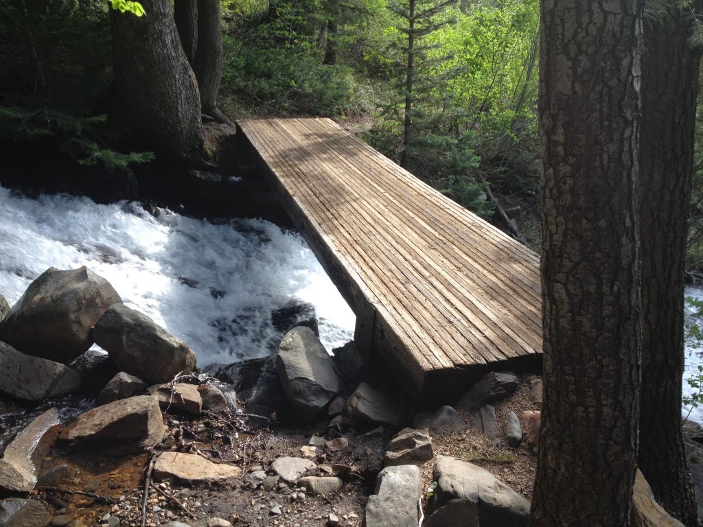
About a mile in I started to hear the roar of the river and it was loud. Usually a roar like that only accompanies a waterfall. I caught a couple glimpses of the river through the trees and was impressed by the quantity of water coming down the mountain.
Fortunately there was a bridge across the river at about 1.2 miles and I was able to cross. I took a few pictures as I crossed and got a little dizzy seeing all the water roaring beneath me.
As I recall, the trail stays somewhat flat for a bit after crossing the bridge and for quite awhile the hiking is very pleasant. There were multiple times on this trail that I said to myself that that part of the trail was absolutely perfect. The trail was pretty soft in most places, had good shade, great smells. and occasional views. It was a great trail. Except for the parts that were too steep to be enjoyable, but even then all the other factors nearly made up for the steepness.
About a half mile from the bridge I entered the lower meadow. The trail dipped down a couple dozen feet (which is always a little frustrating because you know you have to make that elevation up again somewhere) and I had a short, flat respite from the relentless climbing.
According to my records, this meadow sits at about 7500', which is about 700 feet above the bridge just a half mile back. The upper meadow (my final destination) sits at 8200', another 700 feet up, and just a half mile further. That's an average slope of about 26%.
I was excited to reach the upper meadow, and not just because I knew I was finished climbing. It was beautiful to look back and see the canyon I'd just climbed, and look forward and see the snow on the peaks towering another 3000' over me. I spent some time exploring, taking some pictures, and eating a snack. I briefly considered hiking a bit farther but talked myself out of it when I saw the sun dip behind the mountain.
The trip down was uneventful and much faster than I expected. I saw 3 people within a half mile of the trailhead, two going down and a third coming up. It seems strange to me that with over 1 million people living within an hour of this trail I could be the only person that day to spend time in that meadow. I'm not complaining--I like the solitude--but it still boggles my mind how few people make the effort to get out and explore with so many beautiful places so close to home.
In all, I hiked 5 miles and climbed 2300'. It was a difficult hike but worth it in every way.