Wednesday night I was finally able to get out after work and do a real hike. I've done a couple low elevation hikes this Spring but none of them were really worth writing about.
I was a bit unsure where to go. There's still snow in the highest elevations, and I've done a lot of hikes the last couple years. I didn't really want to repeat a hike when there are so many more to do.
After weighing my options I finally decided to head up the Broads Fork trail. It's the trail that leads to Twin Peaks (that tall peak you see between Big and Little Cottonwood Canyons). It was the shortest drive and the most intriguing of all my options.
The trail starts at the bottom of the S-Curve in Big Cottonwood Canyon. It's the same trail head as the trail to Lake Blanche, but instead of going South from the parking lot you go West.
The trail starts out steep and slowly gets steeper. In fairness, it also has a few flat spots. The trail stays in the trees most of the way up, but was a little overgrown in a few places. My legs got scratched up a bit trying to squeeze through the bushes.
I started hiking at about 5:30pm, having driven there straight from
work. It felt great to be back out hiking in the canyons and seeing all
the green in the trees and bushes. I didn't realize how much I missed
the smell of the mountains until I got a half mile in. With the
steepness of the trail I wasn't able to maintain my usual fast pace, but
I still made pretty good time.
After about half a mile I heard some voices ahead of me just off the trail. I noticed there were some cliffs up on the right, and there were a couple guys (20ish) climbing around on them (or I imagined they were climbing around. In reality they were sitting at the bottom of the cliffs when I passed).
One of them asked me if I knew where the trail went. I was tempted to tell him it lead to the parking lot at the S-Curve, but figured he probably wanted to know where the other end of the trail went.
I told him that I wasn't really sure, but had heard that it leads to a couple meadows and eventually a few peaks. They must not have been impressed with my description, or were just lazier than they looked, because I didn't see them at any point higher up the trail. In fact I didn't see anyone else higher up on the trail than that.
About a mile in I started to hear the roar of the river and it was loud. Usually a roar like that only accompanies a waterfall. I caught a couple glimpses of the river through the trees and was impressed by the quantity of water coming down the mountain.
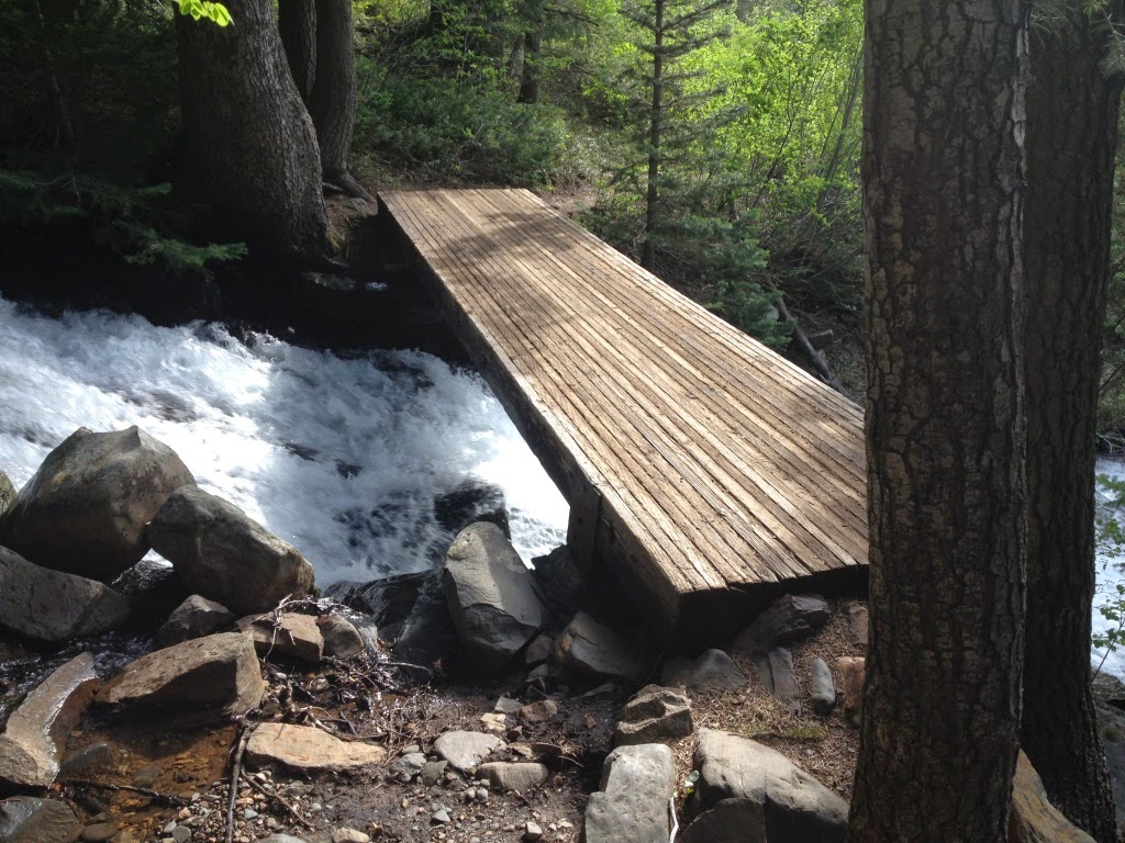
Fortunately there was a bridge across the river at about 1.2 miles and I was able to cross. I took a few pictures as I crossed and got a little dizzy seeing all the water roaring beneath me.
As I recall, the trail stays somewhat flat for a bit after crossing the bridge and for quite awhile the hiking is very pleasant. There were multiple times on this trail that I said to myself that that part of the trail was absolutely perfect. The trail was pretty soft in most places, had good shade, great smells. and occasional views. It was a great trail. Except for the parts that were too steep to be enjoyable, but even then all the other factors nearly made up for the steepness.
About a half mile from the bridge I entered the lower meadow. The trail dipped down a couple dozen feet (which is always a little frustrating because you know you have to make that elevation up again somewhere) and I had a short, flat respite from the relentless climbing.
According to my records, this meadow sits at about 7500', which is about 700 feet above the bridge just a half mile back. The upper meadow (my final destination) sits at 8200', another 700 feet up, and just a half mile further. That's an average slope of about 26%.
I was excited to reach the upper meadow, and not just because I knew I was finished climbing. It was beautiful to look back and see the canyon I'd just climbed, and look forward and see the snow on the peaks towering another 3000' over me. I spent some time exploring, taking some pictures, and eating a snack. I briefly considered hiking a bit farther but talked myself out of it when I saw the sun dip behind the mountain.
The trip down was uneventful and much faster than I expected. I saw 3 people within a half mile of the trailhead, two going down and a third coming up. It seems strange to me that with over 1 million people living within an hour of this trail I could be the only person that day to spend time in that meadow. I'm not complaining--I like the solitude--but it still boggles my mind how few people make the effort to get out and explore with so many beautiful places so close to home.
In all, I hiked 5 miles and climbed 2300'. It was a difficult hike but worth it in every way.
Saturday, June 7, 2014
Sunday, March 16, 2014
Hurricane Rim/Canal Trail
We were still a bit worried about the weather on Saturday, the last day of the trip. The forecast called for a chance of rain throughout the day. However, the closer to Saturday we got the better the forecast looked. When we woke up Saturday morning the 60% chance had dropped to 30%.
It didn't really matter if it rained or not, though. This was the day I had been looking forward to the most and I wasn't going to change my plans. There was no flash flood danger on this trail, and I'd be sleeping in my own bed that night.
On this trip I tried to match my starting points to Mike's starting points so we wouldn't have to drive all over the place every day. I knew he was planning to meet his team in Hurricane so I scoured the internet for hikes in Hurricane. There were quite a few and they all looked pretty good. A lot of them required driving in on a dirt road, though. I eventually settled on the Hurricane Rim trail, with the option of dropping down to the Canal Trail.
Here in Northern Utah there are plenty of canal trails, but they're all just dirt roads running next to stinky canals. This canal trail follows a canal completed in 1904 with tunnels and bridges and stunning views along the whole length.
The trail starts at the Hurricane Hills trailhead just East of Hurricane on Highway 59 (the road to Colorado City). It follows the road to the East for awhile, then switches back up the hill. There's quite a bit of up and down, but no steep places. It was exactly the kind of trail I like.
At 1.85 miles the Canal Trail split off from the Rim Trail. My original plan had been to do a loop, following the Rim trail to the far end where it met with the Canal Trail, then return on the Canal Trail. That would have been at least 11 miles and I had read that there were some washouts on the Canal Trail that might have made a few of the miles difficult.
Instead, I decided to hike the Canal Trail as far as I could, backtrack to the Rim Trail, then continue up the Rim Trail to make up the miles. So I took the turnoff for the Canal Trail and dropped quickly down to the level of the canal. It was amazing to see something so old that was still mostly intact. The canal was still mostly in the shape of a canal, often with a steep drop off the side.
Within a few hundred feet I came to the first tunnel. It was neat to see, but a little short for a tall guy like me to walk through. Fortunately there was a way around the tunnel. The tunnel was a couple hundred feet long. It's pretty amazing to think about people being able to carve that out over a hundred years ago.
I followed the Canal Trail about a mile before I had to make another decision. There were a couple tunnels that had collapsed and the only way to get around was to drop down to the Virgin River hundreds of feet below, then climb back up to the canal farther up the canyon. After having already hiked 20+ miles in the last 48 hours I wasn't confident that I'd be able to climb back up from that far down; I had to leave enough strength to get back up from the canal, too.
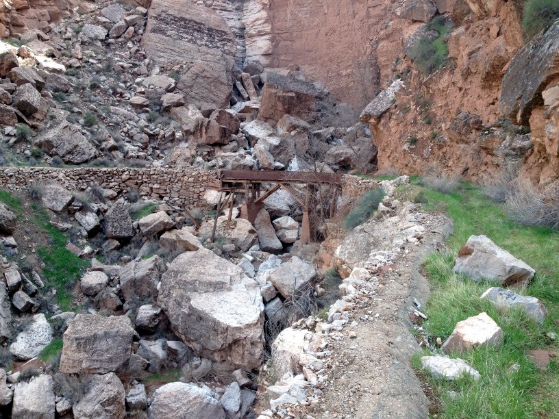
So I decided to turn around and head back up to the Rim Trail. I got to see a couple tunnels, an old bridge, some great scenery, and walked a mile in a 100-year-old canal. That was enough.
The views along the Rim Trail were even better than I could have imagined. It felt like I could see forever in all directions. The rain over the last couple days had cleared the air so there was no haze, and the remaining clouds made for some beautiful pictures.
I think I took nearly 100 pictures on just this one trail. Every time I turned a corner the views got even better.
I'm sure these pictures aren't in order, but it all looked about the same.
There were a lot of cows out grazing. It was a lot more pleasant to come across cows in the light than it was in a dark a couple years ago up on Big Mountain. They're still pretty freaky to see when you're all alone. I always just talk to the cows now (in English. I don't speak Cow) and it seems to help.
I hiked another 2 miles up the Rim Trail so I could end up with a total of 10 miles by the end of the hike. I also climbed nearly 2,500 feet over the course of the hike, even though my end point probably wasn't more than 100 feet higher than where I started.
That put my trip total at 28 miles in 3 days. It was an amazing trip.
It didn't really matter if it rained or not, though. This was the day I had been looking forward to the most and I wasn't going to change my plans. There was no flash flood danger on this trail, and I'd be sleeping in my own bed that night.
On this trip I tried to match my starting points to Mike's starting points so we wouldn't have to drive all over the place every day. I knew he was planning to meet his team in Hurricane so I scoured the internet for hikes in Hurricane. There were quite a few and they all looked pretty good. A lot of them required driving in on a dirt road, though. I eventually settled on the Hurricane Rim trail, with the option of dropping down to the Canal Trail.
Here in Northern Utah there are plenty of canal trails, but they're all just dirt roads running next to stinky canals. This canal trail follows a canal completed in 1904 with tunnels and bridges and stunning views along the whole length.
The trail starts at the Hurricane Hills trailhead just East of Hurricane on Highway 59 (the road to Colorado City). It follows the road to the East for awhile, then switches back up the hill. There's quite a bit of up and down, but no steep places. It was exactly the kind of trail I like.
At 1.85 miles the Canal Trail split off from the Rim Trail. My original plan had been to do a loop, following the Rim trail to the far end where it met with the Canal Trail, then return on the Canal Trail. That would have been at least 11 miles and I had read that there were some washouts on the Canal Trail that might have made a few of the miles difficult.
Instead, I decided to hike the Canal Trail as far as I could, backtrack to the Rim Trail, then continue up the Rim Trail to make up the miles. So I took the turnoff for the Canal Trail and dropped quickly down to the level of the canal. It was amazing to see something so old that was still mostly intact. The canal was still mostly in the shape of a canal, often with a steep drop off the side.
Within a few hundred feet I came to the first tunnel. It was neat to see, but a little short for a tall guy like me to walk through. Fortunately there was a way around the tunnel. The tunnel was a couple hundred feet long. It's pretty amazing to think about people being able to carve that out over a hundred years ago.
I followed the Canal Trail about a mile before I had to make another decision. There were a couple tunnels that had collapsed and the only way to get around was to drop down to the Virgin River hundreds of feet below, then climb back up to the canal farther up the canyon. After having already hiked 20+ miles in the last 48 hours I wasn't confident that I'd be able to climb back up from that far down; I had to leave enough strength to get back up from the canal, too.
So I decided to turn around and head back up to the Rim Trail. I got to see a couple tunnels, an old bridge, some great scenery, and walked a mile in a 100-year-old canal. That was enough.
The views along the Rim Trail were even better than I could have imagined. It felt like I could see forever in all directions. The rain over the last couple days had cleared the air so there was no haze, and the remaining clouds made for some beautiful pictures.
I think I took nearly 100 pictures on just this one trail. Every time I turned a corner the views got even better.
I'm sure these pictures aren't in order, but it all looked about the same.
There were a lot of cows out grazing. It was a lot more pleasant to come across cows in the light than it was in a dark a couple years ago up on Big Mountain. They're still pretty freaky to see when you're all alone. I always just talk to the cows now (in English. I don't speak Cow) and it seems to help.
I hiked another 2 miles up the Rim Trail so I could end up with a total of 10 miles by the end of the hike. I also climbed nearly 2,500 feet over the course of the hike, even though my end point probably wasn't more than 100 feet higher than where I started.
That put my trip total at 28 miles in 3 days. It was an amazing trip.
Tuesday, March 4, 2014
Padre Canyon
On Friday the weather got worse. Clouds rolled in overnight and the weather people were all saying that it would start at 10:00am and last into the evening. Mike's ride got changed to 9:00am to try to stay ahead of the weather, and we doubted whether or not we'd even leave the hotel.
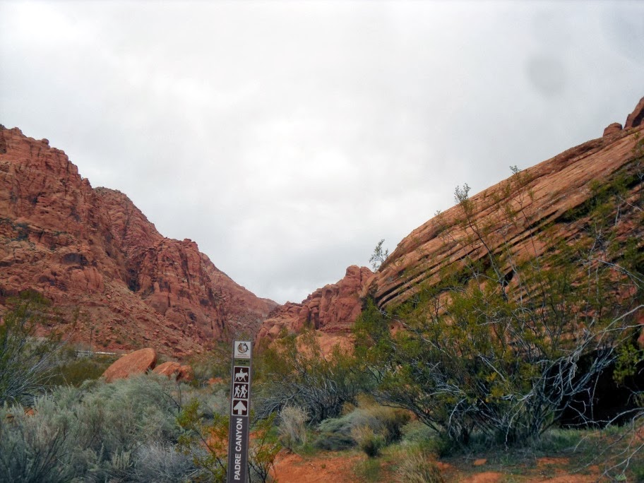
By 8:00am we decided to head out and hike together. It's a lot easier to stay warm hiking than riding a bike. My planned hike for the day was hiking from Snow Canyon to Padre Canyon (where Tuacahn is) and back to Snow Canyon over the mountain.
I didn't realize how much of a climb it would be to get out of Padre Canyon. It was a 600 foot climb in less than half a mile to get to the top of the pass. There were also a lot of ups and downs on the way to Padre Canyon.
It was neat to see Tuacahn from behind. The rock formations were amazing.
I took a picture of a big cactus for my son. He's obsessed with cacti. Yes, you read that correctly.
This is a panoramic picture from the top of the pass with Tuacahn on the left and Snow Canyon on the right.
The whole hike we could see the clouds forming to the South, but we didn't get rained on until we were a half mile from the car.
My original plan was to head North in Snow Canyon to see more of the park, but by the time we made it down from the pass and slogged through miles of deep sand we decided to take the shortest route back to the car. We could tell the clouds wouldn't hold off much longer, and could see the rain falling in the distance.
We made it back to the car after 6.5 miles hiked and 1250 feet climbed. It was a beautiful trail but we felt rushed the whole time and probably didn't take enough time to enjoy it. Plus we were really hurting by the end. That put me up to 18 miles in about 25 hours That was enough.
By 8:00am we decided to head out and hike together. It's a lot easier to stay warm hiking than riding a bike. My planned hike for the day was hiking from Snow Canyon to Padre Canyon (where Tuacahn is) and back to Snow Canyon over the mountain.
I didn't realize how much of a climb it would be to get out of Padre Canyon. It was a 600 foot climb in less than half a mile to get to the top of the pass. There were also a lot of ups and downs on the way to Padre Canyon.
It was neat to see Tuacahn from behind. The rock formations were amazing.
I took a picture of a big cactus for my son. He's obsessed with cacti. Yes, you read that correctly.
This is a panoramic picture from the top of the pass with Tuacahn on the left and Snow Canyon on the right.
The whole hike we could see the clouds forming to the South, but we didn't get rained on until we were a half mile from the car.
My original plan was to head North in Snow Canyon to see more of the park, but by the time we made it down from the pass and slogged through miles of deep sand we decided to take the shortest route back to the car. We could tell the clouds wouldn't hold off much longer, and could see the rain falling in the distance.
We made it back to the car after 6.5 miles hiked and 1250 feet climbed. It was a beautiful trail but we felt rushed the whole time and probably didn't take enough time to enjoy it. Plus we were really hurting by the end. That put me up to 18 miles in about 25 hours That was enough.
Red Cliffs / Prospector Trail
The perfect situation got a little complicated with the addition of an enormous rain storm blowing through the area. The weather became the most important issue of the weekend; we had to try to avoid the rain and wind as much as possible, and for me especially there was the possibility of flash flooding in the canyons I'd be hiking in.
I spent weeks trying to determine the right hikes for the weekend. I wanted to hike in the same general area where Mike was riding so we wouldn't have to drive all over southern Utah to make things work. For the first day (Thursday) I decided to hike the Red Reef trail, and connect onto the Prospector trail, returning to the road to the Red Cliffs Recreation Area where the hike had started.
To get to the Red Cliffs Recreation Area we exited at exit #22 (probably). It was the Leeds exit, and there were signs for the RCRA. The signs led us under the freeway. There wasn't much room to get through as you can see above. What you might not be able to see is all the tumbleweeds that half blocked the tunnel. The wind was blowing pretty hard, and it was raining on and off.
Right near the trailhead I saw this sign. I think it was for cars, but it made me a bit more aware that there was the possibility of flash flooding up this canyon and I'd need to be careful.
Mike dropped me off and I buckled my pack and started up the trail. It was very easy to follow and not very steep at all. There was plenty to see: red cliffs, near-arches, spectacular formations.
I made a deal with myself that I would continue up the trail as long as there was someplace I could climb to higher ground if the water started to rise. I was able to do that for 3/4 of a mile or so, and then I reached the pools.
I had come to a spot where you have to climb up into a bowl mostly filled with water, and climb out on the other side. The walls on both sides were easily 30' tall and straight up. There was no escape. To make it just that much more intimidating it was impossible to see upstream. The stream took a sharp turn as it dropped into the bowl.
In the end, I just couldn't justify the risk. I'm sure nothing would have happened, but not knowing the trail above that point, and not being in the area long enough that day to know where rain had been falling, it just wasn't a risk I was willing to take.
And I knew that a mile or so down the road I could pick up the Prospector Trail. I knew this because that's where I had planned to end the hike. The only problem was that I didn't know how far I'd have to go on the Prospector Trail before I could get to a place to be picked up. The trail mostly followed the freeway so I told myself I could just hop the fence and get to the freeway that way if needed.
On the first part of the journey, I was looking at all the life. There were plants and birds and rocks and things. There was sand, and hills, and rings. It seemed very much like hiking in the desert. The trail stayed pretty flat the whole way; there were ups and downs, but no sustained climbing. I'd heard that it's a popular mountain biking trail, but I didn't see any mountain bikers on it. Not one. The rain probably kept them away. It rained on and off for the first couple hours. At one point I was more wet than dry, but that didn't last long.
I'd read something about the Prospector Trail linking up with the Church Rocks Trail, but I didn't know how people accessed the Church Rocks Trail. (The above picture is of some of the church rocks area.) I had to pull out my phone and do some searching to find a trail that would get me back to the other side of the freeway.
I came across a website that said that the best access to Church Rocks was from the Coral Hills subdivision at Heritage Park. The directions were to ride from the park on the trail along the freeway to the water tank at the top of the hill, then ride down the other side of the hill and cross I-15 through a creepy culvert. I just had to reverse the directions and do it all on foot. At this point I was coming up on 9 miles and it looked like the water tank was another mile away.
While I was trying to figure all this out the skies cleared up and it turned into a spectacular day. The only complaint I have about hiking in St George is the lack of clouds. I've never seen a cloud there in all the times I've visited. I don't want the clouds for shade; I want the clouds to add some personality to my pictures.
You can see the water tank in the picture above. It's actually on a hill behind the hill you see there.
There's a closer shot, along with the freeway in front of it.
I just had to get through that culvert first. It was spooky. On a mountain bike you could just ride through it in seconds. On foot it was nearly 200 feet long and it sounded like there were mice running around. The whole flash flood thing was still on my mind, too, with each and every step.
I made it through, and climbed up to the top of the the hill with the water tank just to climb back down the other side. I didn't realize it would still be a mile before I could get to a road to be picked up.
In all, I walked 11.5 miles and climbed 1200' with all the ups and downs. Just hiking the Prospector Trail starting from the Red Cliffs Recreation Area road to the Coral Hills subdivision would be a couple miles shorter. It ended up being a beautiful day and a great start to the weekend.
Wednesday, October 30, 2013
The Wave
A few months back I got a call from my friend Kristin. She said that she had a life-changing opportunity for me. The last time she called with a life-changing opportunity it led to a new job so I decided I should pay attention.
Her husband, Steve, had applied to permits to hike to the Wave, a rock formation just over the Utah border into Arizona. They do a lottery 4 months in advance for 10 permits, and another lottery the day before for an additional 10 permits. That means that only 20 people are permitted to hike to the wave every day.
Originally they had wanted to take their 2 daughters so they got the permit for 4 people, but as the reports of deaths at the Wave continued to come in all summer they started to rethink their plans. Instead of taking their daughters they decided to take a doctor and a knowledgeable outdoorsman. I guess I was supposed to be the knowledgeable outdoorsman.
Our permit was for October 16th. You may remember some of the drama surrounding the government shutdown during October, specifically the closure of National Parks and other public lands. We'd heard that anyone that had already been issued a permit was still able to go, but that they weren't issuing the day-before permits. We also heard that the rangers were still patrolling as much as usual and weren't holding back on $1200 fines for trail poachers.
We left the Salt Lake Valley around 4:30pm and drove non-stop to Fillmore where we ate dinner at Costa Vida. It tasted pretty good. We were livin' the Vida Costa. After dinner we continued down I-15 to Highway 20 and popped over to Highway 89. By the time we got to Panguitch it was dark and we missed the scenery of the scenic byway, but we made good time to our hotel in Kanab.
The next morning we left by 8 or so (I really can't remember when) and drove about an hour to the turn off to the trailhead. They say that the road is impassable when it's wet; we were thankful it was dry. We drove about 8 miles down the dusty dirt road to the enormous parking lot. We each visited the pit ATM and crossed the road to head down the trail.
For the first mile or so there was actually a trail and it was nearly impossible to get lost. At a certain point, though, we came upon a 50' wide wash and completely lost the trail on the other side of it. I don't think we lost the trail really. It's more like the trail just wasn't there any more.
We walked on the formation above for quite awhile. It was almost like having a sidewalk etched right into the side of the hill. About a mile and a half in we were able to see the landmark that we needed to aim for to get to the wave. The directions that were provided with our permit were very similar to the directions the 3 Amigos received to find El Guapo. I felt silly not bringing my pistola so we could summon the invisible swordsman. If you look in the picture below there's a black crevice in the white rock in the distance, right in the center of the picture. Our directions were to head directly for that.
The directions also said to go to the right of the formation below. This ended up being a good landmark to help us find our way back.
After another mile of hiking we came to the "Steep Sandy Hill", according to the directions. It certainly lived up to its name. I'm not sure we gained more than a couple inches of elevation for every step we took. It was a workout.
At the top of the steep sandy hill, though, we came to the entrance of the Wave.
I think we stayed at the entrance to the wave for at least 30 minutes just taking pictures and admiring the rock. Just that one small part was amazing.
There are a lot of similar sandstone formations that are made from many years of water eroding the rock. The wave is very different; it was formed by wind. Having been formed by wind gave it a much different feeling than similar formations I've seen that were formed by water. It's hard to even describe how it feels to be there.
After our 30 minutes at the entrance, we ventured down a corridor to the right. There were so many colors in the rock. There were bright yellows, oranges, reds, purples, and everything in between. The light was shining just perfectly to illuminate everything and bring out the vibrant colors.
We finally made it out to the famous view of the Wave; the one in all the pictures and that's used as a default Windows wallpaper. We spend another hour or so taking pictures there and climbing all over the rocks to get different views.
Later, on our way back, we regretted not taking a picture of all of us doing the wave. You know, like in a stadium. We didn't even take pictures of ourselves waving hello. We were seriously under-prepared in the funny photo department.
We ventured on past the Wave to some other formations. Our information was a little less detailed for the other formations, but we had a rough GPS track to help guide us. I figured we could explore all we wanted and still find our way back.
I believe the picture above shows the Second Wave, but we didn't recognize it as such when we were there. It was beautiful, but it didn't seem any more impressive than anything else out there. I had a theory that it was impossible to take a bad picture out there, and after looking at more than 230 pictures I think that theory is now confirmed.
After we'd stopped to eat some lunch we made our way back to the car. We ended up hiking about 8 miles overall, and made it back home by 9:30pm. The whole trip was less than 30 hours and was indeed one of the best experiences of my life. Thanks again to Kristin and Steve for inviting me along. They say hiking to the Wave is a once-in-a-lifetime experience. Let's hope that's not true in my case.
Her husband, Steve, had applied to permits to hike to the Wave, a rock formation just over the Utah border into Arizona. They do a lottery 4 months in advance for 10 permits, and another lottery the day before for an additional 10 permits. That means that only 20 people are permitted to hike to the wave every day.
Originally they had wanted to take their 2 daughters so they got the permit for 4 people, but as the reports of deaths at the Wave continued to come in all summer they started to rethink their plans. Instead of taking their daughters they decided to take a doctor and a knowledgeable outdoorsman. I guess I was supposed to be the knowledgeable outdoorsman.
Our permit was for October 16th. You may remember some of the drama surrounding the government shutdown during October, specifically the closure of National Parks and other public lands. We'd heard that anyone that had already been issued a permit was still able to go, but that they weren't issuing the day-before permits. We also heard that the rangers were still patrolling as much as usual and weren't holding back on $1200 fines for trail poachers.
We left the Salt Lake Valley around 4:30pm and drove non-stop to Fillmore where we ate dinner at Costa Vida. It tasted pretty good. We were livin' the Vida Costa. After dinner we continued down I-15 to Highway 20 and popped over to Highway 89. By the time we got to Panguitch it was dark and we missed the scenery of the scenic byway, but we made good time to our hotel in Kanab.
The next morning we left by 8 or so (I really can't remember when) and drove about an hour to the turn off to the trailhead. They say that the road is impassable when it's wet; we were thankful it was dry. We drove about 8 miles down the dusty dirt road to the enormous parking lot. We each visited the pit ATM and crossed the road to head down the trail.
For the first mile or so there was actually a trail and it was nearly impossible to get lost. At a certain point, though, we came upon a 50' wide wash and completely lost the trail on the other side of it. I don't think we lost the trail really. It's more like the trail just wasn't there any more.
We walked on the formation above for quite awhile. It was almost like having a sidewalk etched right into the side of the hill. About a mile and a half in we were able to see the landmark that we needed to aim for to get to the wave. The directions that were provided with our permit were very similar to the directions the 3 Amigos received to find El Guapo. I felt silly not bringing my pistola so we could summon the invisible swordsman. If you look in the picture below there's a black crevice in the white rock in the distance, right in the center of the picture. Our directions were to head directly for that.
The directions also said to go to the right of the formation below. This ended up being a good landmark to help us find our way back.
After another mile of hiking we came to the "Steep Sandy Hill", according to the directions. It certainly lived up to its name. I'm not sure we gained more than a couple inches of elevation for every step we took. It was a workout.
At the top of the steep sandy hill, though, we came to the entrance of the Wave.
I think we stayed at the entrance to the wave for at least 30 minutes just taking pictures and admiring the rock. Just that one small part was amazing.
There are a lot of similar sandstone formations that are made from many years of water eroding the rock. The wave is very different; it was formed by wind. Having been formed by wind gave it a much different feeling than similar formations I've seen that were formed by water. It's hard to even describe how it feels to be there.
After our 30 minutes at the entrance, we ventured down a corridor to the right. There were so many colors in the rock. There were bright yellows, oranges, reds, purples, and everything in between. The light was shining just perfectly to illuminate everything and bring out the vibrant colors.
We finally made it out to the famous view of the Wave; the one in all the pictures and that's used as a default Windows wallpaper. We spend another hour or so taking pictures there and climbing all over the rocks to get different views.
Later, on our way back, we regretted not taking a picture of all of us doing the wave. You know, like in a stadium. We didn't even take pictures of ourselves waving hello. We were seriously under-prepared in the funny photo department.
We ventured on past the Wave to some other formations. Our information was a little less detailed for the other formations, but we had a rough GPS track to help guide us. I figured we could explore all we wanted and still find our way back.
I believe the picture above shows the Second Wave, but we didn't recognize it as such when we were there. It was beautiful, but it didn't seem any more impressive than anything else out there. I had a theory that it was impossible to take a bad picture out there, and after looking at more than 230 pictures I think that theory is now confirmed.
After we'd stopped to eat some lunch we made our way back to the car. We ended up hiking about 8 miles overall, and made it back home by 9:30pm. The whole trip was less than 30 hours and was indeed one of the best experiences of my life. Thanks again to Kristin and Steve for inviting me along. They say hiking to the Wave is a once-in-a-lifetime experience. Let's hope that's not true in my case.
Subscribe to:
Posts (Atom)