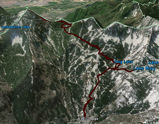
Last Thursday I went for a quick hike right after work. Well, a "quick hike" that was 7 miles and took 3 1/2 hours. That's quick, right?
This year the hardest part of my hiking habit has been picking the right place to go. Last year I hiked a lot of the trails that I've wanted to hike for years, so I've had to do more research to find hikes that fit my hiking style.
Whenever I'm not sure where to go, I start my search in Big Cottonwood Canyon. Since it has been so hot lately I wanted to head somewhere high up the canyon, so I ended up at Brighton, right at the top of the canyon.
I took the Lake Mary trail to the junction with Dog Lake about 2/3 of a mile up the trail...
Then took the fork to Clayton Peak about 100 feet from the first junction.
The Clayton Peak trail heads East from Dog Lake and crosses a ton of ski slopes. It was neat to be in the trees for awhile, and then pop out onto a ski slope and have incredible views of the canyon. And every now and then I passed under the chair lifts.
The trail was in great shape the whole 3 miles to the top. In fact, from the descriptions I'd read about the trail, I thought there would be a lot more rock hopping toward the top. The trail went right to the top, but it got pretty steep the last half mile or so.
The above picture is the first good view I got of Clayton Peak. You can see a road a few hundred feet below the top, and a ski lift off to the left side.
One of the concerns I had on this hike was the afternoons thunderstorms we've been having the last couple weeks. The clouds spit on me a bit most of the way up, but I wouldn't even classify the precipitation as "sprinkles". I was on the lookout for lightning the whole time, too. Annie was a bit nervous about the possibility of lightning (I guess I was too) but I reassured her that I'd turn around at the first sign of lightning.
After about 2.25 miles the trail arrives at Snake Creek Pass, and from
there you climb another 750 vertical feet over .75 miles. That's a
little misleading, though. You hike half that distance on a pretty flat
road, then climb 750' over .30 miles or so. It's steep. It's a climb. If
you don't feel up to climbing to the peak, the views are still just
about as good from Snake Creek Pass.
On the last climb the trail stays on the West side of the ridge about halfway up, then at a certain point it shifts over to the East. It's really easy to miss the shift, though, because the trail seems to continue up the West side. Look for the cairn pictured above to know when to switch over to the East side of the ridge.
I was getting a little concerned near the peak. There were clouds flying across the sky all over, many of them dropping tons of rain. The wind also picked up and knocked me off my feet a couple times. I still didn't see any lightning, though. At the top there's a nice little mailbox wedged into the rocks with some notebooks in there so you can sign in. Apparently a lot of people like to leave granola bar wrappers in it. I guess the .01 ounces is too much weight to carry downhill. Whatever.
I was rewarded for my effort with some amazing views. I could see all the way to Mount Timpanogos to the South, down into the Heber Valley to the East, and all of Big Cottonwood Canyon to the West. When I got to the peak I saw my first glimpses of the sun. It started peaking out from behind the clouds creating beautiful shadows on all the mountains all around.
I lost count of all the lakes I could see from the peak. I could see Lake Mary, Twin Lakes, Silver Lake, Lackawaxen Lake, Bloods Lake, and Lake Brimhall. There could have been others, too, but it was hard to tell with the shadows.
On the way down the wind stopped, the rain stopped, and the mosquitoes went away. I was feeling so good and moving so fast that I decided to take the short detour to Dog Lake.
Then I took the long detour to Lake Mary, just to make sure it was still there. It was, and it still looks great.
In all, I hiked almost exactly 7 miles and climbed 2400 feet in 3.5 hours. Not a bad little hike for a weeknight.


No comments:
Post a Comment