When I woke up Friday morning I knew I wanted to go for a hike right after work, but I had no idea where to go. I didn't feel like climbing to any tall peaks, and didn't feel like driving up the steep Little Cottonwood Canyon road. I thought that maybe there would be a hike worth doing up Millcreek Canyon, but worried a little about finding a spot to park, and then still having to pay the $3 fee to drive through the ugliest of the three canyons. Did I just say that?
After a little lunchtime research I determined that Big Cottonwood Canyon held the answer. I still wasn't completely sure where I'd go (I thought maybe Little Water Peak) but I knew I could get there (and there would be plenty of parking) from either Butler Fork or Mill D North. I also saw an intriguing post about going up Butler Fork to the Mill A Basin, then returning on the Desolation trail to God Lake. That seemed like the way to go.
I've gotten to the point where I don't like hiking back down the same trail I hiked up. Sure, the scenery changes a little because you're walking the same way, but if I'm out to explore new trails why would I walk the same one twice? So this year I've been trying to find loops that I can do, or arrange to have someone pick me up at the end of a long trail and take me back to my car. I hate inconveniencing people, though, so I try to do the loops whenever possible.
I had never really even heard of the Butler Fork trail, but I remember wondering why all those cars were always parked just West of the dogleg in the main road. I'd read that the trail was really steep at first, but that didn't prepare me for how steep the trail actually was.
The picture I took of the steep part ended up a bit blurry, but believe me, it was steep. The steepness only lasted a little while, though, and then it got really pleasant. The trail was a bit overgrown, though. Maybe the steepness scares people off so it doesn't get the use it should. With how pretty the trail is it should be getting a LOT more use.

The trail heads up the canyon for about a mile and then splits; the trail on the right continues up Butler Fork, and the trail on the left heads toward the Mill A Basin. I stood there at the sign for quite awhile weighing my options. Taking the right fork would lead me to Dog Lake in under two miles and I could take the Mill D trail back down with about 4 miles of hiking. Not a bad after-work hike. Taking the left fork would guarantee at least 7 miles of hiking, and would likely be on less-traveled trails. I don't know why it took so long to decide. Obviously the path less traveled by is the one to take, even if it doubles the length of the hike.

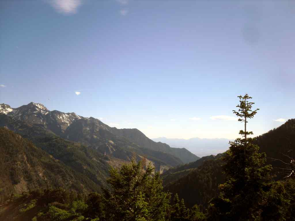
After another half mile (1 mile total, though it seemed like much farther) the trail begins the first of 15 switchbacks to get up onto the ridge. I don't know why they couldn't have added a few switchbacks in before that, but it was nice to finally have some levelish trail. About halfway up the switchbacks there was a great view up the canyon (above) and a pretty good view down the canyon (below).
On one of the last switchbacks (maybe the last; I lost count) there's a faint trail leading to Circle All peak. I decided to take the short (0.2mi each way) detour to see the views (and to say that I climbed to the top of a peak). The short trail was mostly level, and got really steep right near the end. It wasn't at all difficult and the views were amazing. I called Annie to let her know my updated plans just in case things went badly (spoiler alert: they didn't).
The above picture is the view from Circle All peak to the north. You can sort of see the trail I'd be taking later just below the rocks.
Look at all those trees. The above picture is looking West from Circle All peak toward the Mill A Basin. There are so many trees in there.
Annie always encourages me to take pictures of myself while I'm out hiking (probably to prove that I'm not just lifting pictures from the Internet and watching movies or something. I dunno) So here's a picture of me.
Back on the main trail I continued up to the top of the ridge where the
trail turned North. After about a quarter mile walking along the top of
the ridge, the trail split. To the left was the Mill A Basin; to the
right was Dog Lake. I went to the right.
This section of trail was absolutely beautiful. It may be my new favorite place in all of the Wasatch mountain range. There were so many trees and great views and birds chirping and complete solitude that it's hard to imagine a better place to go hiking. Well, except that the trail is a bit overgrown. Maybe "a bit" is underselling it a little. The trail is very overgrown, but it was always easy to find; it just took a bit of extra effort to push the bushes that looked like they may be poisonous out of the way.
I could seriously spend all day staring at trees like this.
The above picture is my favorite of the 50+ pictures I took on this hike. It's my Sacred Grove picture.
The trail contoured around the mountains back to the East. In the above picture, you can see Circle All Peak just to the right of the tree in the foreground (the big one). To the right of the peak is the ridge I hiked North on, and from there I hiked 3 miles to where I took this picture. The canyon at the bottom of the picture is Butler Fork; that's where I would have come up had I taken the right fork in the trail early on.
Is it possible to get tired of seeing pictures of trees like this? Maybe. This is the last one, I promise.
The Desolation trail met up with the Butler Fork trail about a half mile before Dog Lake, which meant that I had to make another choice: go down Butler Fork or continue on to the lake and descend Mill D. At this point I had already hiked 5 miles; it was only about 2 miles to descend Butler Fork, but I'd miss the lake, and I knew it would be at least another 3.5 to take Mill D (1/2 mile to the Lake, 2 miles to the road, and another mile ON the road). The fact that you just saw a picture of Dog Lake should let you know what decision I made. And if you zoom in on the picture of the lake you may be able to see a deer right in the middle.
I watched the sun set through the trees over the lake, then headed down the trail.
It was interesting to finish the hike a mile up the road from where I started it. It started to get dark as I walked back to the car, and there were cars speeding down the canyon, so I decided to put my headlamp on backward with the red lights flashing so nobody would run me over. Or at least so nobody would
accidentally run me over.
I made it to the car just after 9pm, having started the hike just before 5pm, for a total time of 4 hours 15 minutes. I hiked 9 miles (almost exactly) and climbed 2,600 feet (most of that in the first 1,5 miles) to reach an elevation of 8,850 feet. I also stood on top of Circle All Peak and walked around Dog Lake. And I reaffirmed that Big Cottonwood Canyon is definitely my favorite of the three.


No comments:
Post a Comment