Who would have thought I'd be able to hike on November 30th? I had
hung up my backpack for the year and wasn't planning to do any more
hiking till next spring, but the weather this week has been so great I
figured I couldn't pass up the opportunity to get out and hike again.
I
don't think that I've been up Millcreek Canyon since I was a cub scout,
so I was pretty excited to go check it out. Maybe it looks better when
there are leaves on the trees, but I wasn't overly impressed. It was
fine, and I tried to enjoy it, but it's just not my favorite canyon.
The
trail to Grandeur Peak starts at the top of the Church Fork picnic
area. What I didn't realize is that the Church Fork picnic area closes
for winter, so you have to park out on the main road, adding another
steep 1/2 mile of hiking to the day. That was fine, though. At least
there was no traffic on the road.
Once
I got on the actual trail I really started to enjoy the hike. The trail
follows a stream for about a mile or so, and I was a little surprised
at how much water was in it this time of year. I guess the snow that
fell a couple weeks ago is melting off and filling the stream. It was
nice to have the sound of the water to hike next to.
There were a couple "bridges" over the stream as the trail continued to climb.
About
2/3 of a mile up the trail (or 1 1/3 miles for me, hiking from the
road) the trail takes a hard left and starts switching back up to the
ridge, leaving the stream behind for good. It was at this point I
realized there was quite a bit of snow on the ground.
The
trail went up and up, switching back and forth along the mountain,
until at about 2 miles from the start of the trail (or 2.5 for me) the
trail hit the top of the ridge and I could see down into Parley's
Canyon.
It
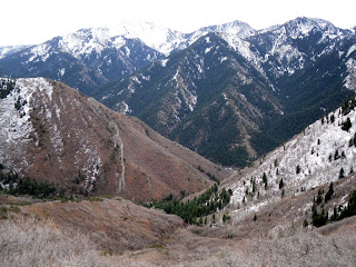
was interesting to look South and see all the snow on the mountains.
Looking from South to North it looks like the mountains are all pretty
much snow-free, but looking North to South they're covered.
The
above picture shows Mount Olympus to the far right, and the picture
below continues showing the ridge between Millcreek and Big Cottonwood
Canyons. One of my goals for this winter is to learn all of the peaks
and protuberances in the Central Wasatch Mountains so I can look smart
and point out what peaks are in the pictures, but I can't do that yet. I
just barely figured out which canyon is which!
After
another half mile of hiking I got my first glimpse down into the Salt
Lake Valley. It wasn't a great glimpse, but pretty good.
From
that point on, though, everything was covered in snow. I had hit a few
small patches here and there, and there was a bit of ice on the trail,
but it didn't look at all fun to continue on through the snow. I
probably could have made it to the peak--it looks like a lot of other
people have since it snowed--but it's just not worth the risk. On the
whole hike I only saw 7 other people and three dogs, and most of those
were just milling around near the bottom of the trail, appearing unable
to make it to the top. There was little chance that anyone would be climbing to the peak after me so if I fell or got injured nobody would even know.
I
did have great cell phone reception up there, and I
always hike with my HAM radio, just in case, but it simply wasn't worth
the risk. I've decided that I enjoy the hike a lot more than the
destination, and risking my life for a slightly better view and some
bragging rights just doesn't make sense to me.
The hike
down was pretty uneventful. It's amazing how sometimes you don't notice
how steep a trail is until you hike back down. It was a stinking steep
trail.
In all, I hiked 6 miles--3 up and 3 down--and
climbed 2100 vertical feet. It wasn't my favorite hike of the year, but
it wasn't too bad, either.


No comments:
Post a Comment